Tukupetsi Trail near the Santa Clara, Utah near the Santa Clara River is one our most frequented hikes in the area.
What to Expect on Tukupetsi Trail

The trail begins simply—an open dirt lot, a few signs, and wide desert sky. Nothing dramatic at first glance.

A quick pause at the trailhead gives you everything you need—map, conditions, and a reminder that this area is more remote than it looks. Cell service drops quickly, and the terrain shifts as you move in.

The map lays out the bigger picture—the Santa Clara River cutting through layered desert terrain. Once you start walking, you realize how much of this landscape is hidden until you’re inside it.

Crossing through the gate feels like a threshold. The signage shifts from guidance to protection—this land holds both ecological and cultural weight, and it’s treated that way. From here the trail verse off in a few different directions. Stay left for Tukupetsi, move along the ridgeline to eventually meet up at Anasazi!

The trail begins to drop, opening up to a green corridor below. A farm sits tucked into the river basin—an unexpected pocket of life against the dry, rolling hills above.


Spring shows up in small, precise ways here—delicate blooms pushing through rock and sand. You have to look down to see them, but once you do, they’re everywhere.

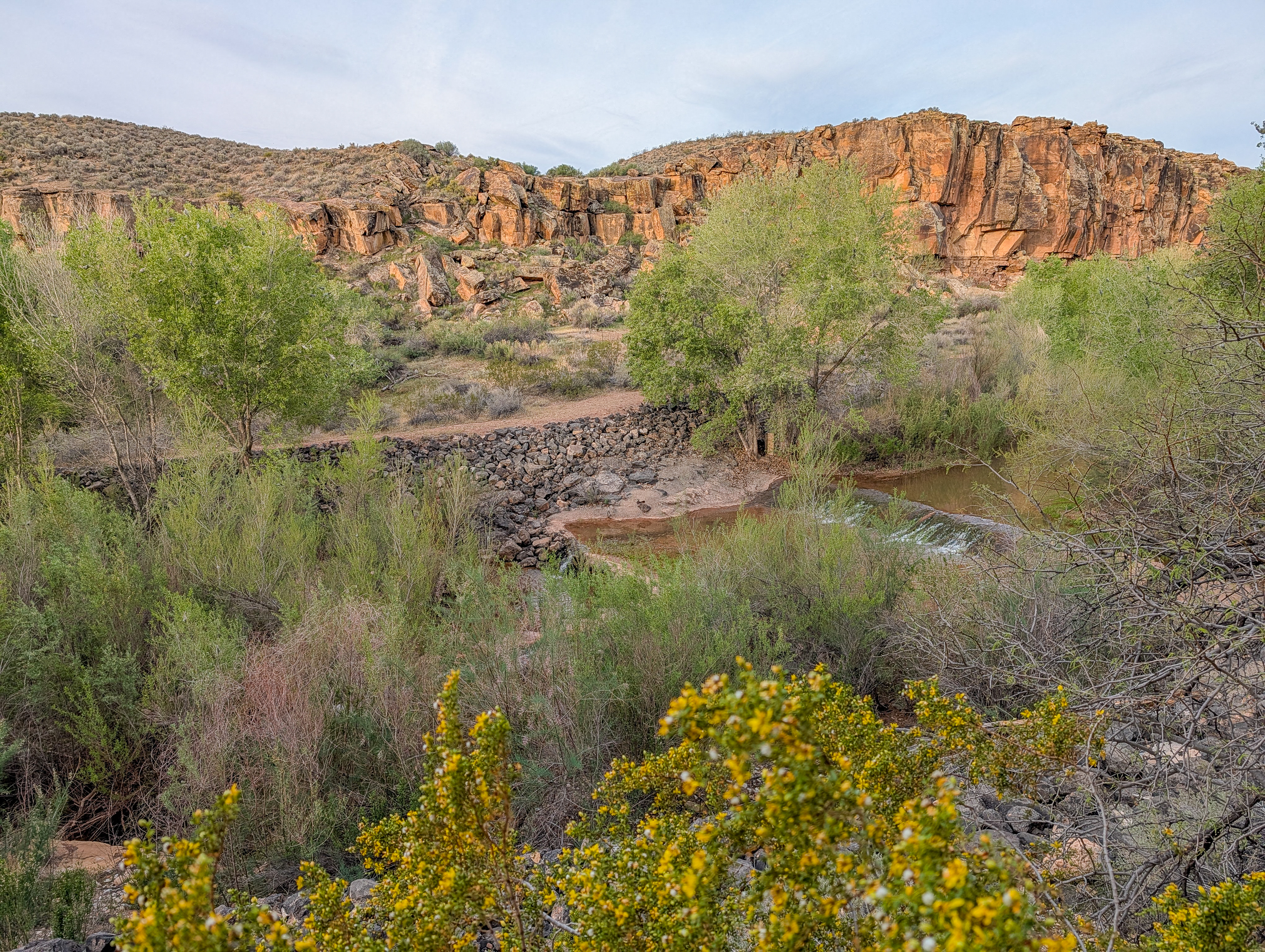
As you approach the river, the landscape shifts dramatically. Red basalt cliffs rise up behind dense vegetation, and the sound of water begins to carry through the canyon. We love to cool off here in the warmer months.

The markings on these cliffs aren’t decoration—they’re preserved history. The reminder is simple: look, don’t touch.

Up close, the rock tells its own story—layers of volcanic stone, fractured over time, with lichen slowly reclaiming the surface. It’s subtle, but constant.. and the petroglyph here- a snake?

The basalt walls feel massive when you stand beneath them. Vertical lines, broken edges, and deep color shifts—this is the backbone of the entire trail.

Once you reach the river corridor, everything softens. Cottonwoods line the path, the air cools instantly, and the trail becomes louder with the sound of frogs, geese, and the river.
Remy, is not about to stop to take it in! She insists we keep moving.

Spring isn’t just flowers. Cottonwood branches are filled with caterpillar nests—clusters of movement tucked into silk. Some stay in the trees… others, try to cross the trail.

This section is one of my favorites. Filtered light, dense growth, and the constant sound of water nearby—it’s an entirely different environment from where you started.

Even the trees hold detail. Fungal growth climbs the bark in layered formations—quiet, slow processes shaping the landscape just as much as water and wind.

Tucked into the base of the cliffs is something unexpected—a car that’s been here for years. It’s out of place, but somehow absorbed into the landscape now- something you have to see in person!

Some carvings stand out immediately—figures, animals, patterns. Others are worn almost flat. You find yourself slowing down, scanning the rock, trying to catch what’s left.

The path continues along the base of the cliffs, winding through desert brush and pockets of green. Remy keeps leading, occasionally checking back like we’re the ones holding things up.

The trail opens again, giving you a wider view of the river corridor—layers of vegetation, red rock, and open sky all stacking together.

The trail keeps a steady rhythm here—packed red dirt, low brush, and cliffs rising just off to the side. It’s an easy stretch, but still visually grounded in the canyon walls.

Off the trail, the vegetation gets more complex—mesquite branches twisting low and wide, layered with lichen and debris. Even a tumbleweed caught in the mix, like it just stopped mid-roll.

Some of the rock formations feel almost carved rather than eroded—pitted, hollowed, and textured like bone. Wind and water working slowly over time.

Spring hits hardest in contrast—sharp spines, soft blooms. Bright pink flowers pushing out of something built entirely for survival.

Pulling back, you see how these bursts of color sit inside a much harsher environment—rock, dust, and scattered grass. It makes the blooms feel even more intentional.

The river opens up here, winding through dense green growth. From above, you can see how much life it supports—everything gathering along its path.

Closer to the water, the movement becomes more visible—clear flow, shallow edges, and thick vegetation pressing in from both sides.

Some of the most detailed petroglyphs appear on larger boulders like this—dense with markings, patterns layered over time. You can stand here for a while and still keep noticing more. My favorite- the sun looking one!

Small and easy to miss, but precise—purple blooms rising straight out of the red soil. Another reminder that spring here happens at ground level.

Massive stones like this sit almost independently of the cliffs—fractured off at some point, now just part of the terrain. Solid, quiet, and unmoving…and if you look closely, more very petroglyphs!

Some surfaces are covered edge to edge—lines, shapes, figures that don’t resolve immediately. You don’t always know what you’re looking at, but you know it matters.

Down by the Santa Clara River trees, water, and light all expand outward. It feels less enclosed, more breathable.

Perfect spot to stop and take it all in.

The trail narrows as it pulls you back into the trees. Soft ground, filtered light, and that immediate temperature drop again—it’s a noticeable shift every time. This trail takes you all the way to the Anasazi trailhead.

This one stands out—bright, oversized compared to the rest of the plant. Almost disproportionate, but beautiful and impossible to miss.

This trail doesn’t rely on one standout feature—it’s the constant shift that makes it. Open desert to shaded river, hard basalt to soft growth, quiet detail to wide views. It’s one of the few places where you can move through multiple environments in a single walk—and leave feeling like your pace adjusted to something slower.
If you want to experience this hike from a higher perspective definitely check out Anasazi Trail! Grab a bite after you’re done hiking in Kayenta Art Village in Ivins! Or cool off in the Ivins Firelake!
By Merievy Oborn
How to get There + Local Tips
- From I-15 Exit 6 turn north on Bluff Street.
- Turn left on Sunset Blvd.
- Continue on Sunset Blvd as it turns into Santa Clara Drive (Old Hwy 91).
- Continue ~0.5 miles past the Jacob Hamblin Home
- Turn left onto a graveyard Wash that leads to the Tukupetsi Trailhead.
- Best in spring along the Tukupetsi Trail in Santa Clara, Utah, especially when flowers are blooming and in the fall when the leaves turn yellow.
- Dog -friendly
- Watch for heat in the summer
Leave a Reply